
Bortle Sky Classification
The Bortle dark-sky scale (usually referred to as simply the Bortle scale) is a nine-level numeric scale that measures the night sky's brightness of a particular location. It characterizes the observability of celestial objects, taking into account the interference caused by light pollution.
Amateur astronomer John E. Bortle created the scale and published it in the February 2001 edition of Sky & Telescope magazine to help skywatchers evaluate and compare the darkness of night-sky observing sites. The above world sky-at-night map shows areas of light pollution with the brightest regions in yellow and red. This data was compiled in 2024 and it is obvious at least one half to 2/3 of the US is riddled with light-polluted skies.

This image courtesy of ESO/P. Horálek, M. Wallner shows what the Milky Way looks like under the various Bortle skies from 1-9. Most people in the world will never see a sky darker than about Bortle 7.

This is a local Bortle map of the area surrounding my remote observatory in Pie Town, New Mexico, shown by the "+". We're at around Bortle 1-2. Pretty dark! ClearDarkSky.com lists hundreds of observing sites in North America where you can see the locations of many dark sky sites.
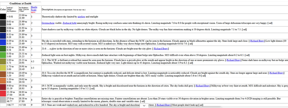
This graphic also found at ClearDarkSky.com gives you a detailed color-coded breakdown of the Bortle Scale.
So what is the take home message here? The dark night sky is a dwindling resource and we have no idea how long before the dark sky sites that are still accessible will remain dark. Get out and experience them while you can! The Bortle data is established worldwide and you can determine what the scale will be for any location on Earth. Probably a search using AI will be helpful. Plan your campsites accordingly!
Thanks for reading!
DrDave